

Topography Definition
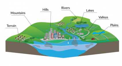
Topography is the study of the land surface. In particular, it lays
the underlying foundation of a landscape. For example, topography refers
to mountains, valleys, rivers or craters on the surface.
The origin of topography comes from “topo” for “place” and “graphia” for “writing”. It’s closely related to geodesy and surveying which are concerned with accurately measuring the land surface. And it’s also closely tied to geography and mapping systems like GIS.
Elevation is the distinguishing factor for topographic maps. In GIS,
we use digital elevation models for terrain. Nine out of ten topographic maps show contour lines, which are just lines of equal elevation. The narrow definition of topography is specific to the arrangement of landforms.
But in a broader sense, it incorporates natural and artificial
features. For example, topographic maps often tie in administrative
boundaries, cities, hydrography, parks, landmarks, transportation and
buildings.
Relief and Contours
Contour lines (isolines) connect points of equal elevation. By
reading contours, we interpret height, slope and shape in topographic
maps.
If contours are close together, the slope is steep. But when contours are spread apart, the slope is more gradual.
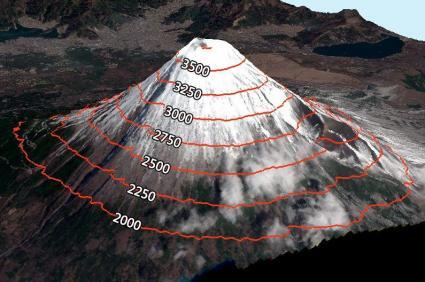
We use contours for mountains, valleys and bathymetry. For example,
Mount Fuji stands at 3,776 meters above sea level. At 250-meter spacing,
each contour line represents equal elevations. Almost at the peak of
Mount Fuji, it’s a 3,750 meter contour line.
Examples of Topography in Maps
There’s no “world authority” in topographic mapping. Instead each
country sets their own standards and priorities. Most often the case,
each mapping agency designs their topographic maps with a specific goal
in mind.
For example, constructing a new highway might drive a topographic map to feature woodland cover, soil types or rock classification along the route. Over time, topographic map series often get periodic updates. But the truth is, they can be complex and take years to create.
In the United States, the first USGS topographic map
was surveyed in 1892. Since then, map revisions have continued for over
125+ years. The USGS produce topo maps at 1:250,000, 1:100,000,
1:63,360 and 1:24,000. The most common is the 7.5 minute quadrangle
series where one inch in the map represents 24,000 inches on the ground.
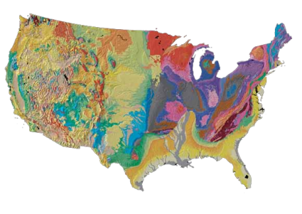
Another example of a topographic map is the USGS Tapestry of Time and Terrain.
In this colorful map, it overlays topography (hillshade) with
underlying rock formations. This helps unravel the geologic history of
the continent, such as mountain building events.
Topography Applications and Uses
Topographic maps show how rivers flow, how high mountains rise and how steep valleys descend. They lay out the land such as in these examples:
- Engineers use topographic maps to plan a road, construct a cell tower or plan a hydroelectric dam.
- Geologists use topography to understand tectonic activity, landforms and where to dig a mine.
- Hikers use topographic maps to find trails and steepness of slope to plan their ascent.
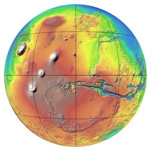
- Astronomers study the topography outside Earth like on the moon, Mars or an asteroid.
- Climate scientists tie topography into climate models to recognize air and water flow.
As landscapes evolve and technology advances, topographers face an uphill battle for accuracy and completeness.
Topography Analysis

If you want to perform any type of topographic analysis, we highly recommend SagaGIS.
It’s completely free and open source. Specifically, the Topography
Analysis Toolkit is a perfect fit for most types of landscape analysis.
It’s so good that you can’t find most of these tools in commercial
software. In particular, it includes a range of morphometry, hypsometry
and other specialty tools. Tools like ruggedness, slope, aspect and
curvature can really characterize the terrain.
If you want to classify the types of landforms, SagaGIS has
out-of-the box tools that do just that. Lastly, we use the topographic
position and wetness index to characterize drainage patterns. Here’s our guide to SagaGIS for more tips and tricks.
SRC: gisgeography


